
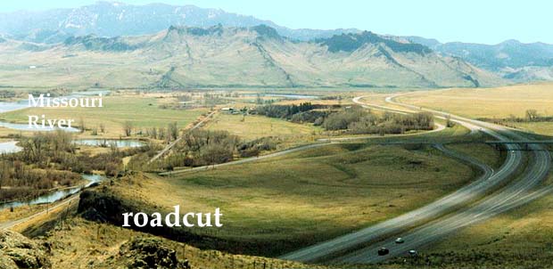
 Above: This photo was taken 20 miles southeast of Crown Butte, near the town of Cascade. The ridges in the photo are "dikes" like those that delivered magma from the volcano to the buttes (laccoliths). Move your cursor over the image to see the locations of the dikes. The dikes join here like spokes on a wagon wheel, indicating that this region was the source of the magma. Pressure from this magma chamber caused cracks in the sedimentary rock that surrounded it. Then dikes formed as magma from the volcano quickly filled these cracks. The magma cooled and became rock, and this igneous rock was more durable than the sedimentary layers that it cut across. So, millions of years of erosion has worn the sedimentary rock away, leaving the igneous dikes standing as ridges in this area. The locals refer to them as "reefs", although their formation had absolutely nothing to do with coral reefs.
Above: The ridges (dikes) are the red lines shown on the map. The blue arrow shows the vantage point that the photo was taken from. If it had been taken 70 million years ago, the photo would have featured a volcano on the surface above the dikes. (Remember, the dikes were formed below the surface.)
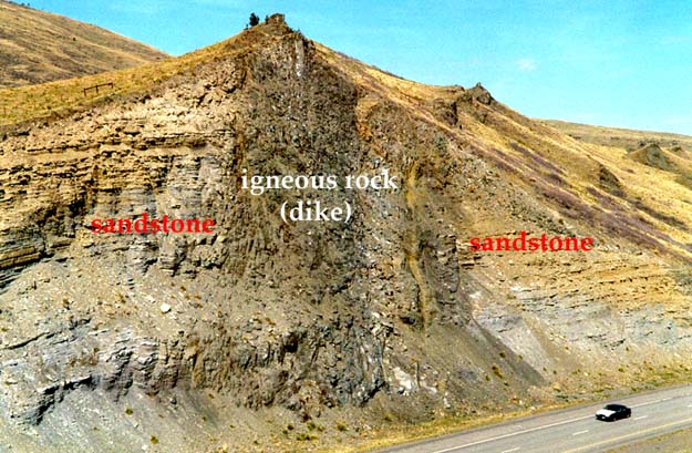 Above: This, taken in the same area as the one at the top of this page, shows one of the dikes that has been exposed in a road-cut. The same road-cut is labeled in the photo at the top of the page. This view is from the opposite side. Dikes are abundant in the area between Cascade and Simms, and along the interstate between Cascade and Craig, where they cut through older igneous rock. They are especially prominent in the cliffs along the Missouri river near Dearborn, which is near the middle of the ancient volcano.
|
 |
8. Columns of rock |
