|
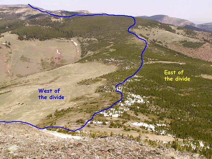
Lewis and Clark Pass on the Continental Divide 
Photo by Rod
Benson
On their return trip from the Pacific in 1806 the Lewis and Clark
Expedition split up. Clark’s party set out to explore what is now
southern Montana, while Lewis took nine men on a more northerly route
to investigate a short cut over the mountains and then explore
north-central Montana. The Corps learned of the short cut from Indian
tribes west of the divide who used it to travel east of the
mountains where they could hunt buffalo.
Familiar landmark . . .
On July 7, 1806, as the Lewis party reached the pass shown in this
photo they recognized a landmark from their westward journey through
the Great Falls area during the previous summer . . . a prominent butte
that they had named Fort Mountain (see photo at bottom of page). It
was a welcome sight, not only because it meant they were on their way
home, but also because it meant that once again they would be able to
enjoy an abundance of buffalo meat.
If they had only known . . .
The explorers soon realized that if they taken this route on their
route to the Pacific they would have saved 50 days, avoiding one of the
most difficult segments of their journey. After crossing here, the men
pursued buffalo and other game, and explored the area northwest of
modern day Great Falls, before returning to the Missouri river near the
Great Falls of the Missouri.
A famous line . . .
The blue line on the photo marks the approximate location of the
Continental Divide. A lower place that offers an easier crossing of a
divide or mountainous is referred to as a “pass”. This one is named
“Lewis and Clark Pass” even though Clark was never there. Water that
runs off east of the divide will end up in the Gulf of Mexico by way of
the Missouri and Mississippi Rivers, whereas runoff west of the divide
flows toward the Pacific through the Blackfoot, Clark Fork, and
Columbia Rivers.
Below . . .
This is photo was taken looking northwest from the highway between
Great Falls and Cascade. Today “Fort Mountain” (15 miles west of
Great Falls) is called Square Butte. This is confusing because there is
a similar butte 35 miles east of Great Falls, also named Square Butte.
The smaller butte in the photo below is called Crown Butte. 
Terms: a "divide", runoff
| 


