|
Chinook Arch over Helena, Montana

Image courtesy of
bigskywalker.com
A Mountain Wave.
This photo was taken from the Helena High athletic fields, looking west toward the Continental Divide. It shows a classic Chinook arch that appeared on December 13, 2018. The clear area between the arch and the mountains exists because the air is down-sloping there. As air flows over the Rockies it may develop an up and down motion like water flowing over rocks in the rapids of a river. Although the air flows downward once it gets over the mountains, it may continue to oscillate up and down as it flows away from the mountains for several hundred miles. The upward flowing part of this "mountain wave" is what forms the long arch of clouds. CLICK HERE to watch a 24-second video of the arch shown in the photo.
Here's how it works.
As the air flows down-slope, it is warmed by compression. Then, as the wave action continues and the air begins to rise again, the air cools by expansion. If there is enough vapor in the air, the arch of clouds will form as vapor condenses to form cloud droplets (or cloud crystals). Typically, the long area of clouds will form near the crest (top) of the first wave and then get blown eastward by higher level winds. If the mountain wave continues, and another downward turn is taken, the arch (cloud) will evaporate farther downstream (east).
Same arch, different vantage point.
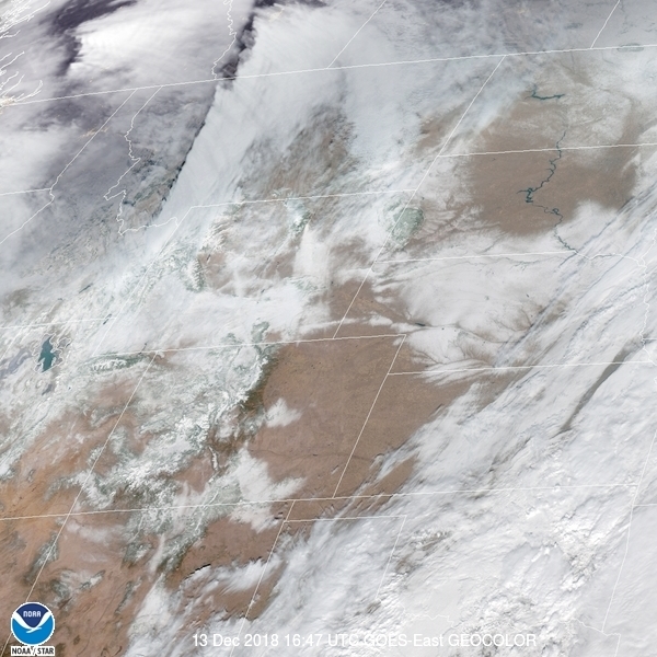
The G.O.E.S. East satellite image below shows what the same Chinook arch looked like from space at 9:47 am MST. It is called an "arch" because an observer standing below it sees a curved patch of clear sky between the band of clouds and the mountains below. In the satellite image, the Chinook arch is the distinct eastern edge of the bright white cloud that extends from north to south through western Montana.
 Photo of a Chinook
Arch By Donovan Watson
Term: oscillate
| 


