|
A Remnant of the Last Ice Age
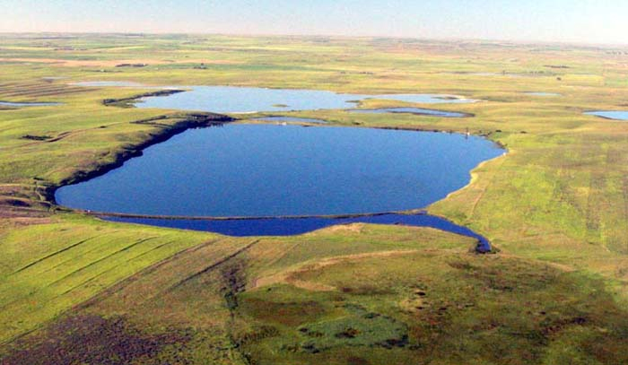 Photo by Jim Rea, Courtesy of Fish, Wildlife and Parks
Note: The Brush Lake article was written by Doug Smith of Dagmar Montana. He allowed me to make some changes so the article would be similar to other pages on this web site. The article appeared in the Queen City News and other newspapers as part of a weekly column contributed by Rick Graetz.
Treasure State Gem . . .
Aside from its distinctive aquamarine blue color, Brush Lake near Plentywood in the northeastern corner Montana looks like many other lakes on the northern Great Plains. However its depth, chemistry, biology and hydrology stand alone in making this a unique body of water.
Sediments tell the story . . .
For millions of years, before the last ice age, the Missouri River turned north just east of Poplar and flowed northeast to Canada's Hudson Bay. During the last ice age the ice sheets spread south grinding up Canadian bedrock and carrying it south to cover the northern portion of Montana and filling in the old river valleys. First the river valleys were filled with lake bottom clays from the dammed up rivers, then glacial till when the glaciers arrived, and finally with outwash sand and gravels when the ice retreated.
Was Paul Bunyan here? . . .
As the climate warmed and the ice front melted back to the north it continued to send tongues of ice down the old valley, leaving a great block of ice a mile long, a half mile wide and hundreds of feet thick where Brush Lake now sits. The melting ice front continued to wash down great volumes of sand and gravel to bury the huge piece of ice. Eventually a spruce forest grew over the buried, slowly melting ice block (diagram). When it finally melted completely, it left the depression that would become Brush Lake. The spruce trees ended up at the bottom of a 100-foot deep lake. Minnesota is famous for lakes formed this way. Geologists call these depressions "kettles", but legend has it that those in Minnesota are footprints left by Paul Bunyan and Babe (his blue oxen).
Strange hydrology . . .
Groundwater flows easily through the buried outwash gravels and the deeper river terrace gravels. These aquifers, which are used for irrigating farmland in the area, supply Brush Lake with a continuous flow of water through large springs in the lake. Since no streams flow out of Brush Lake, summer evaporation serves as a pump to keep groundwater flowing into the lake. And since evaporation only takes pure water out, the minerals leached from the glacial gravels remain dissolved in the lake and accumulate, giving the lake its distinct color. Certain algae and bacteria thrive in this flow of mineral rich water, taking what they need to grow and deposit the carbonates (limestone) in the form of cones, florets, and reefs on lake bottom. Brush Lake's symbiotic twin is White Lake to the south. It is 4 to 6 feet lower and essentially an evaporation pan for the excess water seeping out of Brush Lake. White Lake is where all the sodium sulfate (alkali) comes out of solution and is deposited. The mineral laden water inflow, offsite evaporation and biotic action keep Brush Lake's water clear and fresh year round. It is one of the few lakes in the world where this dynamic process is found.
Brush Lake's Diary . . .
Being a deep lake (65 feet) in a closed basin, Brush Lake contains a sediment record of value to the scientific study of climate change. Since it first saw daylight 10,000 years ago, Brush Lake has accumulated 45 feet of sediments. Much like tree rings the lake annually deposits a layer of light and dark sediment (called "varves"), which can be used to construct a time line. These layers contain pollen and distinct minerals which allow scientists to determine variations in climate since the ice age. Currently (2008) sediment cores are being studied by a team of scientists who are funded by a National Science Foundation grant. In a few years we should have a better understanding of how climate change has shaped this area of the northern Great Plains.
Catching anything? . . .
Over the years attempts have been made to stock the lake with fish, but with no success. It is theorized that all the oxygen in the groundwater is tied up in dissolving the calcium rich gravels resulting in poorly oxygenated lake water. In addition, Brush Lake's water may be more similar to sea water than fresh water, making it tough for traditional sport fish to survive. That is not all bad, since Brush Lake is being developed as a water recreation area there will be no conflicts between motorboats and fishermen, and no need to worry about stepping on a fish-hook when jumping in for a swim.
The Duck Factory of North America . . .
Brush Lake lies within the "Prairie Pothole Region", which is so important to the well-being of waterfowl populations. CLICK HERE to learn more.
Term: leached
Trivia: Which NBA team is named after "kettles", and why does this team have that name?
| 
