
|
Painting Courtesy of Monte Dolack
May of 1805 . . .
When Dinosaurs Wandered the Area . . . Same Layer, Different Location . . . When the coast was located farther to the west, the sea would have been somewhat deeper here. As a result of this deeper environment, this would have been a time when smaller particles such as silts, and clays were deposited here. Those materials make up the layer known as the Marias River Shale shown in the smaller photo of the Eagle Creek area below as well as on the painting. To see why alternating layers of sandstone and shale might be present, watch this animation. Be sure to watch both parts of the animation. To see 40 photos from a trip through the White Cliffs (Coal Banks to Judith Landing; 3 days - 2 nights) in October 2012, CLICK HERE . 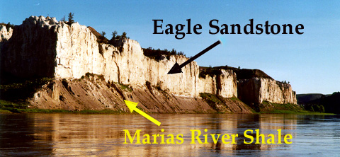 Mountain Building (and the subsequent erosion) to the west of here provided an abundant source for the sands, silts, and clays deposited in this part of central Montana. The rock layers seen along the river tilt gently to the east, so as travelers move downriver (eastward), they see increasingly younger rock layers along the river. Below: This photo, taken about 25 miles downriver from the one above, shows the Eagle sandstone beneath the younger Claggett shale. The shale is made of finer sediments, which were deposited when this area was deeper and farther from the shore. (Photo by Jim Schulz) Even farther downriver, the Eagle sandstone is below the surface so it cannot be seen along the river.  Term: fluctuating Interested in learning more about this area? . . . |
 |
Impressive Photos of the White Cliffs Area on Someone's Blog Site |
|
*More about the geology of the White Cliffs Area |
|
Many More Montana Earth Science Pictures |
|
Earth Science Teacher at Helena High School |
