|
Blame it on El
Nino 
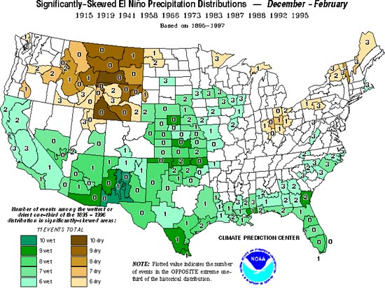
Map
courtesy of NOAA Oceans do affect Montana . . .
The map
shows how El Nino events affect precipitation
amounts throughout the lower 48 states.
According to the information above the map,
there were 11 "strong" El Ninos from 1895 to
1997. The various colors show which areas
tend to experience more winter precipitation
during El Nino years and which ones tend to
be drier. For instance, Montana and Wyoming
tend to be drier during El Nino years, whereas
New Mexico tends to receive more
precipitation as a result of El Nino. The
darkest brown color in south-central Montana
tells that 10 of the 11 El Nino winters were
"dry" for that part of the state. . . In order to be
considered "dry" the winter had to be among
the driest one-third of all winters from 1895 to
1997. The brown that covers most of the state
indicates that 9 of those 11 El Nino winters
were dry in that area of Montana. The "1" in
northeastern Montana indicates that this part
of Montana did have one "wet" winter during
an El Nino year. In contrast to Montana, parts
of New Mexico experienced 10 "wet" winters
during the 11 El Nino years.
So what's the connection? . . .
The El Nino is a change in the
distribution of warm water in the equatorial
Pacific Ocean. Normally the Trade Winds
push the warm surface waters near South
America toward Australia and Indonesia.
This causes an upwelling of cold water along
the west coast of South America, so surface
water there is normally cold. During an El
Nino, the Trade Winds falter or may even
reverse, allowing the warm surface waters to
move back toward South America. During
extreme El Nino events such as the one in
1997-98, the humidity above these warm
waters can cause tremendous rainfall
amounts and flooding in places such as Peru.
On the other side of the ocean, Autralia and
Indonesia may experience droughts and wild
fires. The El Nino also alters the position of
the jet streams, causing storms to track
through the the southern states more often.
With more warm water in the eastern Pacific,
these storms cause higher precipitation
amounts for the southern states. On the other
hand, El Nino tends to leave Montana out of
the loop, as the jet stream diverts storms to
south of the Treasure State.
Term: upwelling, jet stream
|


