|
Classic Squall Line of July 8, 2002 
RADAR can "see" the storm . . .
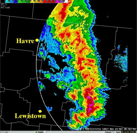
This radar image
shows a squall line that swept through central
and eastern portion of Montana on the evening
of July 8, 2002. Blue areas indicate light
precipitation, green areas indicate moderate
precipitation, and the red areas show where
precipitation is intense. The image was
captured by the National Weather Service's
RADAR device located in Glasgow. The N.W.S.
has RADAR in Glasgow, Great Falls, Billings,
and Missoula. These cities were selected
because they are far enough from each other
to give the N.W.S. good coverage of the entire
state.
Somewhat unusual in these parts . . .
A "squall line" is a line of thunderstorms that
forms along a cold front as cooler air pushes
into very humid, warmer air. Since air in the
Midwest and southeastern United States
tends to be more humid than in Montana,
squall lines are much more common in these
regions.
Rising humid air is the key . . .
Where cooler air is pushing into warmer air
along a cold front, the warmer air rises
because it is lighter. As this warmer air is
forced upward, it cools by expansion.
Eventually the cooling causes the vapor
(humidity) in the rising air to condense,
forming cloud droplets or ice crystals. The
changing of vapor to liquid or solid releases
heat which helps the air continue to rise, and
the cycle continues.
It just kept going . . .
If the warmer air is especially humid as it was
on July 8, a line of dangerous thunderstorms
may sweep through an area. Since this cold
front moved eastward, this squall line also
moved eastward, causing lightning, hail,
strong winds and even a threat of tornadoes
across much of Montana.
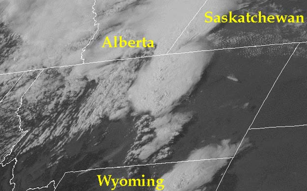
Below: This is a G.O.E.S. East
Satellite view of the squall line at 5 pm MDT on
July 8, 2002. The line of thunderstorms
extends from southwest Saskatchewan
toward northcentral Wyoming.
 Image
courtesy of N.O.A.A.
Term: RADAR
| 


