|
Photo courtesy of Crimson Bluffs Chapter
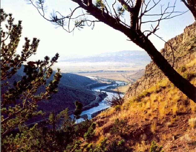
An explorer's perspective . . . “the country was rough mountainous & much as that of yesterday until towards evening when the river entered a beautiful and extensive plain country of about 10 or 12 miles wide which extended upward further than the eye could reach this valley is bounded by two nearly parallel ranges of high mountains which have their summits partially covered with snow”. The beautiful country that Lewis described is the Townsend valley bounded by the Big Belt Mountains on the east and the Elkhorn Mountains to the west. At this point, the expedition was about 30 miles north of the headwaters of the Missouri. The photo was taken from the southern edge of the valley, showing what the explorers would have seen as they looked back at the valley they had just passed through.
A geologist’s perspective . . .
 Diagram courtesy of Mountain Press Publishing White: This is limestone (and marble) made of shells and other forms of calcite, deposited at the bottom of a sea during the Paleozoic Era about 250 million years ago. Before entering this valley, Lewis and Clark Expedition had a close-up view of the same limestone formation as they traveled through the Gates of the Mountains area. Fault: The diagram also shows that the Belt layers and the Madison formation are offset as result movement along the Lombard Thrust Fault. A more recent publication called Roadside Geology of Montana tells that this is a place where the crust to the west was moved about two miles eastward, carrying layers of the Precambrian Belt rocks over younger Paleozoic rocks. This would have happened as the plates were pushing together to form the Rocky Mountains around 75 million years ago (m.y.a.). Today the movement of the plates is pulling this part of the USA apart, causing the block on the left to slip downward causing occasional earthquakes. This is how most of the valleys in western Montana were formed. Pink This granite (and diorite) formed as magma cooled slowly beneath the surface about 75 m.y.a. Over eons erosion have removed less durable rocks from above the granite, exposing it as the mountains between Helena and Butte. The area of hardened and exposed granite is known as the Boulder Batholith. Red: Unlike the magma that hardened beneath the surface to form the Boulder Batholith, the Elkhorns are made of lava that erupted onto the surface. The granites that make up the batholith are referred to as plutonic (intrusive) igneous rocks, whereas the hardened lavas are called volcanic (extrusive) igneous rocks. Erosion has worn away all but the guts of the volcanoes that spewed out the lava. What’s left is referred to as a “volcanic pile”. Days before reaching this valley, Lewis and Clark passed through a similar volcanic pile in the area just west of present-day Cascade, Montana. Green: Beneath the soil of this valley are gravels that have been transported here by streams that originated in the surrounding mountains. The gravels (and sands) consist of pieces that were broken off (weathering) of the Elkhorns and Big Belt Mountains. As ancient streams flowed from the mountains onto the valley floor, they slowed, dropping the larger pieces (gravel and some sand). The smaller pieces, including silts and clays would have continued on with the Missouri River to the Gulf of Mexico, ultimately becoming sediment on the ocean floor. To learn more about the geology of the Townsend area and rest of Montana, find out how to order a copy of Roadside Geology of Montana by clicking on “Books” (see Hot Links below). |
 |
Montana Earth Science Pictures |
|
Books |
|
More about Lewis and Clark in the Townsend Area |
|
Next Picture: Capt. Lewis at the Great Falls |