Montana Earth Science Picture of the Week

A bigger river ran through it.

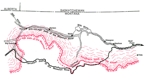
Map courtesy of Mountain Press Publishing of Missoula, Montana

This weeks picture is a map that has been borrowed from Northwest Exposures, a book about the geologic past of the Northwest. The following paragraphs are excerpts from Roadside Geology of Montana. Both books were written by David Alt and Donald W. Hyndman.

It didn't make sense. . .
A few miles east of Havre, the valley of the Milk River abruptly becomes too broad for the stream. From there to its mouth, the little river wanders aimlessly in the spacious floor of a broad valley that it could not have eroded. There is no corresponding change in resistance of the bedrock, so the explanation must involve some event in the history of the river. The first thing to consider is ice. All the countryside north of the Missouri River lay beneath glacial ice at the end of the Bull Lake Ice Age.

A Hand-Me-Down Valley . . .
Shortly after the turn of the century, an early geologist pointed out that the broad valley of the lower Milk River is about the size of the Missouri River below Ft. Peck, and that the Missouri River flows through a narrow canyon for a long distance between Ft. Benton and Ft. Peck. He suggested that the Missouri River may have occupied the broad valley of the lower Milk River until the ice sheet pushed it south. When the ice melted, the Milk River started flowing through the old valley of the Missouri River, which continued to flow in a channel it had established along the edge of the glacier.

The grossly oversized valley of Big Sandy Creek south of Havre is probably part of the abandoned segment of the Missouri River, now filled with glacial sediments. These sediments are the gravels, etc. that were brought here by the glacier and then transported again by water from the melting ice as the ice age came to a close. Another segment of the abandoned valley lies just north of Havre, and is also partly filled with glacial sediments.

Terms: bedrock, stream channel

HOT LINKS

Find out about NORTHWEST EXPOSURES
*Compare the map to an image that shows topography
Next picture of the week

By Rod Benson
Earth Science Teacher at Helena High School

You Are Visitor
***