|
Lost Lake Found North of the Highwood Mountains 
This site does open on many mobile devices. CLICK HERE to watch a 2-minute video: Scenes from Lost Lake.
Not that kind of lake . . .
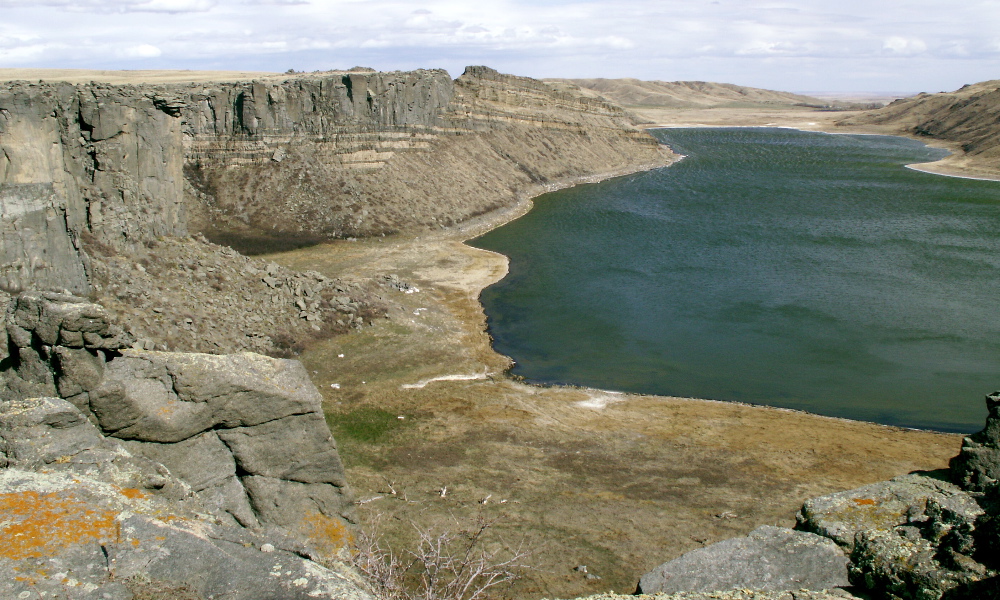
Lost Lake, which is one of Montana's most unique bodies of water, can be found hidden below the surrounding prairie north of the Highwood Mountains, about 30 miles east-northeast of Great Falls. Although it is off the beaten path, and definitely not a destination for fishing or boating, Lost Lake's interesting geology makes it worth the trip. The rocks and 250-ft. cliffs tell of a fascinating past, including a time when an ancient sea covered the area, an episode of volcanic activity, and a more recent period when ice age floods shaped the landscape.
Something has to give . . .
The Missouri River once drained toward the Hudson Bay, but that all changed with the arrival of the ice ages . . . and things in central Montana really got interesting when the ice reached the Highwood Mountains (15,000 to 20,000 years ago). There, the continental glacier pushed up against the Highwood Mountains, blocking the flow of the ancient Missouri River and causing the formation of Glacial Lake Great Falls. According to geologists the lake filled with melt-water and eventually reached a level (3,900 ft. above sea level) where it was high enough to flow over the dam. Overflow from the lake flowed along the edge of the ice sheet through the area north of the Highwoods across existing drainages, carving a channel known today as the Shonkin Sag (Google Earth view). Today the Shonkin Sag is a wide, deep valley with scattered brackish lakes that winds its way between the small towns of Highwood and Square Butte (south of Geraldine). Lost Lake is not part of the Sag's main channel. However, at some point (perhaps in a previous ice age*) flood-waters carved the the cliffs (shown in the photo below), which would have hosted tremendous waterfalls . . . much higher than those found at Niagara Falls today.
CLICK HERE to read an article about Lost Lake (includes some great photos).
Black and white . . .
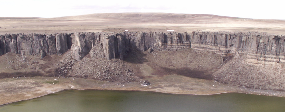
The lighter-colored rocks seen in the cliffs around the lake are layers of sandstone . . . part of the Eagle formation, made from sands deposited during the late Cretaceous Period (over 65 million years ago) when the Western Interior Seaway inundated North America. Dinosaurs wandered along its shores and coastal plains. The Rimrocks of Billings are part of the same formation. The dark cliffs and stripes between the sandstones are igneous rocks, formed as magma cooled underground. Some molten rock did make it to the surface as lava. In fact, many of the mountain ranges in central Montana, including the Highwoods, owe their existence to a time when volcanoes were active in central Montana from 80 to 40 million years ago. The Highwood Mountains are what geologists refer to as a volcanic pile (all that is left of a volcano after millions of years of erosion). The Bear Paws south of Havre, the Elkhorns south of Helena, and the mountains between Craig and Cascade are some of the other remnants of this period of volcanism.
About those stripes . . .
CLICK HERE for a larger version of the photo above and a better view of the stripes. Whenever there are active volcanoes in the area, there is bound to be magma moving around below the surface as well. In some cases the magma works its way into cracks, between layers, or simply melts its way through surrounding rock, hardening before it makes it to the surface. If the magma cuts across layers of sedimentary rocks (or other types) the formation is called a dike. If the magma forces its way between layers of sedimentary rock, as it did here, the formation is called a sill. The dark sills in the cliffs around the lake are associated with a larger formation called the Lost Lake Laccolith, a formation hundreds of feet thick, formed as magma forced its way between layers of sandstone and pooled in a mushroom-shape below the surface.
*The most recent ice age ended about 10,000 years ago. Over the past one million years, Earth has experienced an ice age ABOUT once every 100,000 years.
 CLICK HERE to see a larger version of this photo. Can you can spot my sky blue SUV in the upper left quadrant? Terms: channel, laccolith, brackish
|


