|
Thin-Skinned Thrusts Along The Rocky Mountain Front 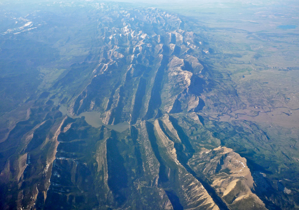
Photo taken by Bobak Ha'Eri, on June 3, 2009 (Wikipedia). The "front" of what? . . .
This aerial photo, which was taken 65 miles west of Great Falls, shows the Rocky Mountain Front; one of Montana's most treasured areas. The Front is the eastern edge of the Rockies and the adjacent prairie, extending from the Simms area (map) northward through Browning into Canada (map). In other parts of Montana, the transition from mountains to prairie is much more gradual, so perhaps the name comes from the fact that travelers heading west across the prairie could see the abrupt "front" of these mountains from many miles away. The Front, which is valued for its beautiful ranches, incredible scenery, and outdoor opportunities, is also recognized as one of the nation's most important wildlife areas. Grizzly bears still wander down onto the plains in the spring and almost all other pre-settlement plants and animals (except the bison) are still present. Migratory waterfowl (photo) use the abundant wetlands found along The Front, and the diverse mix of habitats supports many species.
There's been a disturbance . . .
The ridges in the photo are layers of Madison limestone, made of sediment deposited on the floor of a shallow ocean over 300 million years ago (map). Like many mountains throughout the world, visitors to this range can find fossils of ancient sea creatures thousands of feet above sea level. The presence of mountains and the fossils they contain prove that this part of the Earth's crust was disturbed (a.k.a. "messed up", deformed). Quite often such disturbances involve crustal plates colliding - and that was definitely the case here. From about 80 to 40 million years ago, the Pacific Plate was slowly pushing into the North American plate many miles to the west of Montana (map), inching layers of rock upward and causing scattered areas of volcanism from Mexico to northern Canada. This collision gave rise to the Rocky Mountains. Layers formed on ancient ocean floors were uplifted, folded, faulted, or tilted . . . or all of the above. It can get messy! But these geological messes are the mountains we have today. In contrast, layers beneath the soils of eastern Montana were disturbed very little, so that part of the state is fairly flat.
 Like shingles on a roof . . . Like shingles on a roof . . .
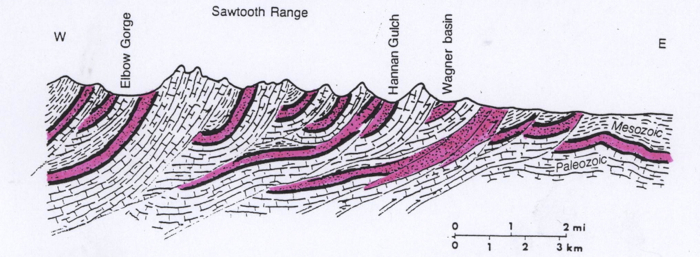
For obvious reasons the part of the Rockies shown in the photo was named the "Sawtooth Range" (#11 on this map). The Sawtooths and other mountains along The Front are associated with of one of Montana's most famous geologic features . . . It's called the "Lewis Thrust Belt", and ever since it was discovered it in the early 1900s, it has been considered one of the world's classic geologic structures. In this thrust belt, fractures formed in sedimentary rock formations and then rock layers on west side of the fault(s) slid up and over layers to the east. Huge slabs of sedimentary rock slid eastward as far as 50 miles, slowly pushed by the same collision that caused the faults. These slabs sit where Glacier Park and the Great Bear, Bob Marshall, and Scapegoat Wilderness Areas are today (map) . However, in the Sawtooth Range the thrust-faulting happened a little differently (see diagram). The slabs that slid up and over were thinner, and there were more faults than were formed to the north and west. Before the thrust-faulting, the fragmented pink areas on the diagram were once a single, continuous, horizontal layer. The long, north-south ridges in the photo above are the upturned edges (another photo) of these thinner slabs of Madison limestone that slid eastward and onto younger rock layers like the shingles on a roof. (Diagram courtesy of Montana Bureau of Mines and Geology Publication: "Profiles of Montana Geology")
What goes up . . .
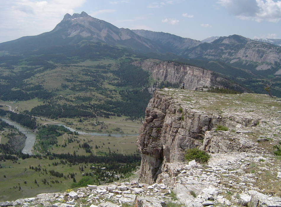
Ever since these mountains started forming, weathering and erosion have been working to wear them down. Rivers from the Continental Divide to the west carved outlets through the thrust-faulted layers, transporting water and sediment to the Missouri River. The Sun River, which joins the Missouri near Great Falls, can be seen in the photo at the top of this page. Gibson Reservoir (also in top photo) on the Sun River stores spring run-off that is used throughout the summer to irrigate farmland between here and Great Falls. The photo below provides a view of the Sun River exiting its canyon on the way to Great Falls. The lone hiker is standing on Castle Reef (Madison limestone) looking south toward Sawtooth Ridge. Can you figure out where these locations are on the aerial photo at the top of this page?
Below: Photo of the Sun River flowing onto the Rocky Mountain Front by Matt Affholter
Term: thrust-fault, converging plate boundary
|

