|
Montana's
Greatest Earthquake Disaster 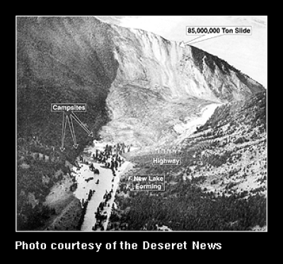
The Night the Mountain Fell* . . .
This photo, taken 20 miles northwest of
West Yellowstone, shows the Madison
Canyon Landslide. The landslide happened
as result of a magnitude 7.5 earthquake near
Yellowstone Park at 11:37 pm on August 17,
1959. Tragically, a campground located on the
Madison River was buried by the landslide,
killing 24 people. Only five bodies were
recovered . . . The rest are presumed to be
buried beneath the landslide. This photo was
taken the day after the quake for the Deseret
News (Salt Lake City).
A new lake is formed. . . .
The fallen mountain also blocked
Highway 287 and dammed the Madison River,
causing the formation of Earthquake Lake
(a.k.a. Quake Lake). There was concern that the
water would eventually overflow and wash
away the landslide. This would have caused
a flash flood in Ennis (40 miles downriver). A
crew from the Army Corp of Engineers cut a
channel through the landslide to prevent this
from happening. Today a visitor center sits on
the landslide, and in places the tops of dead
trees can still be seen poking through the
surface of the lake. NOTE: The Madison
River is a tributary of the Missouri River. The
Madison, the Gallatin and the Jefferson
Rivers join near the town of Three Forks, Montana to
form the Missouri River.
Click here to see what the landslide looks like today (interactive panorama).
Term: Army Corp of Engineers
*"The Night the Mountain Fell" is the title of a book about the disaster. It was written by Edmund Christopherson in 1960.
| 
