Images courtesy of
Tanja Fransen and the National Weather Service Forecast Office in Glasgow, Montana
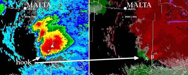
On July 20, 2001 line of severe thunderstorms swept through eastern Montana. The two RADAR images above each show a different aspect of one of those thunderstorms as it spawned a tornado 30 miles south of Malta. The image on the left was made using the RADAR's reflectivity mode. It shows a distinct hook echo, typical of a thunderstorm that might have a tornado beneath it. With the reflectivity mode, radar waves sent out from stations reflect off of precipitation particles, revealing where and how hard the precipitation is falling. As a severe thunderstorm develops an area of rotation (called a meocyclone), the precipitation pattern may develop the hook shape that warns meteorologists that the storm may soon spawn a tornado, if it hasn't already.
The Doppler Effect . . . reds and greens. . .
The image on the right was made using the RADAR's velocity mode. This mode, which also relies on precipitation (and dust) to reflect radar waves, uses the Doppler Effect to determine wind direction beneath or within a thunderstorm. RADAR waves sent to the area marked A are reflecting off of precipitation and dust particles that are blowing toward the RADAR device in Billings, whereas waves sent to area B echo off of particles that are moving away from the Billings station. The result is that waves coming back from area A have a higher frequency (shorter wavelength) than those returning from B. Computers use colors to show the difference between incoming (green) and outgoing winds (red) so that meteorologists can visualize the strong rotation beneath the thunderstorm. The National Weather Service has RADAR devices near Billings, Glasgow, Great Falls, and Missoula.
Bad day in eastern Montana . . .
Although the tornado shown on the radar images was very severe, it happened in a remote area so no one was hurt and very little damage resulted. If the tornado had swept through Billings, or any other town, the death and destruction would have been worthy of national news coverage. The same line of severe thunderstorms that spawned the twister did cause considerable wind damage (not tornadic) to power lines, grain elevators, and a pickup several miles southeast of Circle (see photo below). The storm, which had started at earlier that afternoon in Montana, finally fizzled out the next morning in Minnesota.
Update: In 2011-2012, the National Weather Service upgraded their RADAR system to utilize a new technology called Dual-Polarization RADAR. To learn more about this technology, watch the video below.