|
Layer of Clay is
Focus of
Debate 
Photo
courtesy of Milwaukee Public
Museum
About the photos . . .
These two
photos were both taken in Garfield County
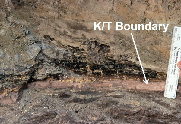
(eastern Montana). The above photo shows
the Cretaceous-Tertiary Boundary . The photo
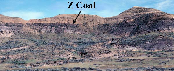
near the bottom of this page shows the layers
of the Hell Creek Formation, one of the
best-known dinosaur "graveyards" in the
world. Paleontologists from all over the world
have visited this area near Jordan to
search for fossils of dinosaurs and other
organisms that lived here during the late
Cretaceous Period over 65 million years
ago.
The K/T Boundary . . .
Of special interest to scientists is a thin
layer of clay that neatly separates layers of
rock laid down in the Cretaceous Period
(when dinosaurs lived) from layers deposited
during the Tertiary Period (after the
dinosaurs). Although this layer of clay, called
the K/T Boundary, has been found in over 100
locations around the world, some of the most
informative exposures are found in Garfield
County.
Formation of the clay that makes up the
K/T boundary . . .
Scientists believe that the K/T clay was formed
from dust generated when an asteroid
slammed into the Gulf of Mexico 65 million
years ago. One reason for this belief is that
the clay contains an abundance of iridium, an
element that is extremely rare in sedimentary
rocks but much more abundant in certain
types of asteroids. Another clue contained in
the K/T clay is "shocked quartz". When quartz
is subjected to violent shock waves is
develops an unusual pattern of tiny fractures.
Shocked quartz is found around known impact
craters, and in the upper part of the K/T
boundary. More proof of the impact came in
1991 when geologists discovered a 110-mile
wide crater buried under 3,600 ft. of sediment
in the Gulf of Mexico near Chicxulub,
Mexico
A debate among scientists . . .
Although there is little doubt among scientists
that an asteroid crashed into the Earth 65
million years ago, there is disagreement
about the role that this played in the demise of
the dinosaurs. Most geologists and some
paleontologists believe that this is what
caused the extinction of the dinosaurs and
many other species. However, other
paleontologists disagree, claiming that
dinosaurs had already begun to die off long
before the impact. In their view the asteroid
was simply the last straw.
Below: This photo shows the Brownie
Butte area in Garfield County, Montana. A layer of coal, called the "Z coal", lies just above the K-T Boundary.
The gray layer beneath the K/T is the Hell Creek
Formation, made up of the last sediments
deposited in the Cretaceous Period (end of
Mesozoic Era).
 Photo courtesy
of David E. Fastovsky, Ph. D.
Professor of
Geosciences at the University of Rhode
Island
Sources . . .
1. Alt, David, and Donald Hyndman.
Northwest Exposures. Missoula,
Montana: Mountain Press Publishing,
1995.
2. Culotta, Elizabeth. "Dinosaurs Path to
Extinction." Earth: Jan. 1993: 24-29.
Term: asteroid
| 


