Montana Earth Science Picture of the Week

Shape of Land to blame for Livingston's Strong Winds

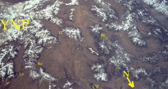
One Montana city known for its frequent strong winds is Livingston. In fact it is common for Livingston to experience "hurricane force" winds (winds that exceed 120 km or 74.4 miles/hour). Wind frequency, direction, and speed are influenced by many factors. But for Livingston, the factor that makes it a standout when it comes to wind is topography. The shape of the land around Livingston gives this city the distinction of being located at the end of two funnels formed by nearby mountains.

To understand this situation, let's first identify the labels on the space shuttle view of southwestern Montana shown above. The white areas on the photo are snow covered mountains, whereas the brown areas are lower elevations; valleys, etc.

YNP: Yellowstone National Park
Lv: Livingston
Bz: Bozeman
Bt: Butte
EL: Ennis Lake
CF: the southern tip of Canyon Ferry Reservoir

Winds from the south . . .
In the winter, the high area in Yellowstone Park becomes very cold. As this air gets cold it also becomes heavier (more dense). Eventually it begins to move down from the high mountains of the park. As it does, the air tends to follow valleys of rivers such as the Yellowstone River, which flows northward toward Livingston. As the cold, dense air flows downhill, it accelerates, and the Yellowstone Valley funnels the air down into Livingston (from YNP to Lv). Next time you travel the interstate from Billings to Bozeman on a cold winter night, check to see if there is a sudden increase in wind from the south as you pass through the Livingston area.

Watch the Convection II Video

The westerlies . . .
Winds are always named by the direction that they are coming from, and in Montana that is usually the west. In Livingston these westerly winds can be especially strong because of the shape of the land to the west of Livingston. About 20 miles to the west of Livingston is the large Gallatin Valley . As air flows from the west, Mountains of the eastern edge of the valley act as a dam. Consequently, the air piles up in the Gallatin Valley in much the same way that water forms a reservoir behind a dam. However, a narrow opening, called the Bozeman Pass, provides a way for that air to get through and continue its flow across the state. So as the weight of air that has built up in the valley pushes air near the ground through the narrow pass, once again Livingston can be right in the path of some pretty amazing winds out of the west. CLICK HERE to see another view of the same area.

Term: topography

HOT LINKS

See past pictures of the week
*Montana Wind Resources
Next picture of the week

By Rod Benson
Earth Science Teacher at Helena High School

You Are Visitor
***