|
Montana
Rocks! 
Map courtesy of
Montana Bureau of Mines and
Geology
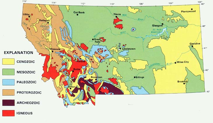
Click here to see a more detailed geologic map. This map uses
color to show the ages of rocks that are at or
nearest the surface throughout Montana. In
most locations the rock (bedrock) is covered
by soils. In some places it is exposed in road
cuts, cliffs, valley walls, canyons,
outcroppings, or on steep mountain slopes.
The Age of the Dinosaurs . . .
Throughout the green area rocks made up
of sediments that were deposited in the
Mesozoic Era lie closest to the surface. This
area is dominated by horizontal layers of
sedimentary rocks such as sandstones and
shales that originated as sands and muds at
the bottom of an ancient sea. Since the
dinosaurs roamed Montana during the
Mesozoic Era (250 to 65 million years ago),
the green area is the best place to find fossils
of dinosaurs. In parts of central Montana the
horizontal layers were intruded by magma
during a period of volcanic activity that formed
some of the isolated mountain ranges in this
part of the state, including the Bear Paws, the
Little Rockies, and the Highwoods. The red
areas on the map indicate the presence of
igneous rock that formed as this magma/lava
cooled. Other periods of volcanic activity
resulted in the presence of igneous rocks at
surface in southwestern Montana.
After the Big Guys Died Off . . .
The eastern portion of the state sits on
sedimentary rock formed from sediments that
were laid down during the Cenozoic Era (65
million years go to present), after the
dinosaurs died off. In this part of the state the
rock layers that would contain dinosaur fossils
lie beneath the rocks of the Cenozoic Era.
The Messy West . . .
Rocks in the western portion of the state
are much different from the well-ordered
horizontal layers of sedimentary rock found in
eastern Montana. Surface rocks in the west
are made up of a variety of older rocks that
have been faulted and/or folded by the
movement of crustal plates, and also intruded
by volcanic activity. The blue areas on the
map are mostly Madison limestone that was
laid down on the floor of a tropical sea about
350 million years ago. The lighter brown
areas are places where you will find
sedimentary and metamorphic rock that
formed between 2.5 and .5 billion years ago.
The oldest rocks in the state (3.8 to 2.5 billion
years old) are represented by the dark brown
on the map.
Terms: Mesozoic Era, Cenozoic Era
| 


