Montana Earth Science Picture of the Week

Ocean Front Property in Montana

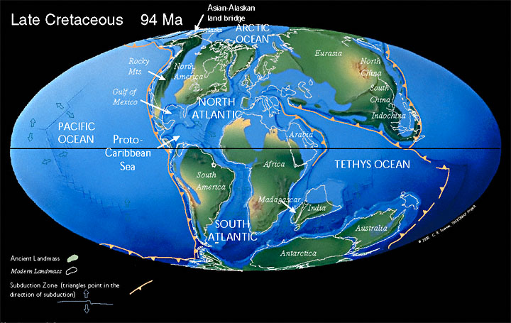
Map Courtesy of Chris Scotese, PALEOMAP Project www.scotese.com

When dinosaurs roamed . . .
During much of the Cretaceous Period (144 to 65 million years ago) a large portion of Montana was covered by the waters of a shallow, inland sea called the Western Interior Seaway. The sea was formed as west-central North America was subsiding to an elevation below sea level. As this sinking occurred the area filled with water from the Gulf of Mexico and the Arctic Ocean.

Source of the sediment . .
Between 80 and 40 million years ago, tectonic forces were building the Rocky Mountains in western Montana and Idaho. Rivers flowing eastward from these mountains transported massive amounts of sediment (sand, silt, clay) to this sea. As the land cycled between periods of uplift and subsidence, the seaway expanded or shrank, resulting in dramatic east-west shifts in the location of the coastline.

Where do I drop you off? . .
Changes in the location of the coastline also caused changes in the type of sediment deposited in different areas. . . Sand was deposited closer to the coast, whereas silts and clays settled to the bottom in deeper waters. Watch this animation. As layers of sand, silt and clay became buried, they were compressed and turned into the sedimentary rocks found today in central and eastern Montana, and throughout the rest of the west-central United States. For example, the "Rimrocks" of Billings are made of sand deposited at or near the shoreline of the ancient Western Interior Seaway.

Source: Monahan, Glenn and Chanler Biggs. Montana's Wild and Scenic Upper Missouri River. Missoula, Montana: Northern Rocky Mountain Books, 1997.

Terms: subsidence, deposition

HOT LINKS

*PALEAOMAP Project (more cool maps)
*More about the Cretaceous Period
Recommended Reading
Next picture of the week

by Rod Benson
Earth Science Teacher at Helena High School

You Are Visitor
***