
|
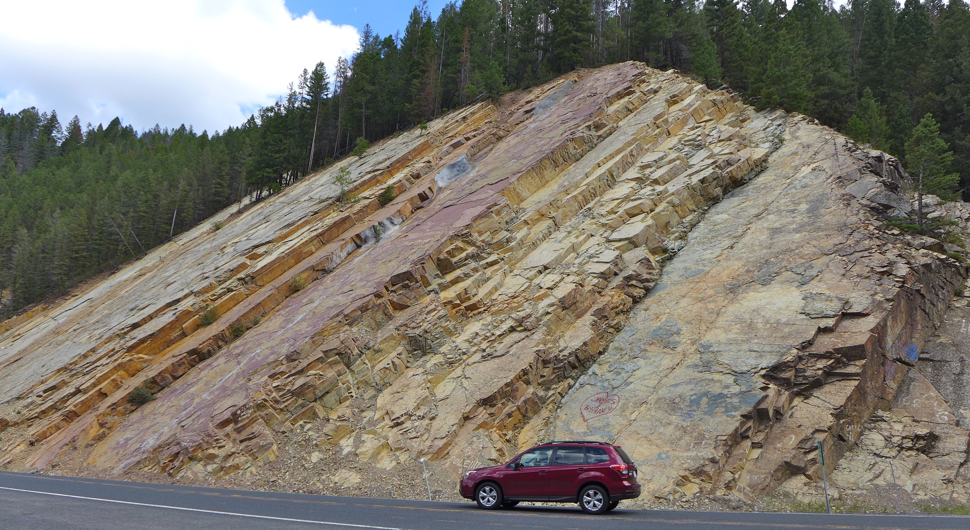
Photo by Rod Benson Above: "Belt Rocks" can be seen throughout much of western Montana, but one of the most interesting exposures can be seen along the Pintler Scenic Highway between Philipsburg and Anaconda. Here (above photo) the layers have been tilted, making the layers look like books leaning against a wall. Sedimentary rocks are formed in horizontal layers, but in northwestern Montana the horizontal layers of Belt rocks were messed up as colliding plates formed the northern Rocky Mountains roughly 80 million years ago. The mountains of Glacier Park formed as a large portion of Belt layers were thrust up and over younger sedimentary rock. Not only did this collision form many of the mountains of western Montana, but it also exposed layers that were buried deep beneath the Earth, giving geologists a look farther back in time.
Must have been quite the basin . . . . Clues in the layers . . . 1. mudcracks: Abundant between layers of Belt rocks; These were caused by surfaces that dried in the sun before being flooded by water that brought more mud or silt, which preserved the delicate features. 2. ripple marks: These suggest the presence of gentle waves in shallow water. 3. no animals: Although the Belt Supergroup includes plenty of extremely primative plants and bacteria, the rocks offer no trace of animal life. This helps explain why features such as mudcracks and ripple marks are so well preserved. There were no burrowing organisms in the Precambrian Era as there was in the more recent Paleozoic Era when sea floor sediments where more likely to be "bioturbated" by mollusks and the like. To see a photo of fossil algae in the Belt Supergroup, click on the Hot Link below. 4. no windblown sand: Although the basin was dry at times, there is no windblown sand. This puzzles geologists and begs the question, "did the wind not blow hard enough to carry sand?" 5. diabase sills: In places molten rock from below forced its way between layers forming sills of hardened magma. Unlike sedimentary rock, scientists can determine the age of igneous rock using radiometric techniques. These dates can help establish the ages of various layers in the Belt Formation. To see a photo of a dabase sill in the Belt Supergroup, click on the Hot Link below. 6. reds and greens: Many of the layers of mudstone in the Belt Supergroup are colored interesting shades of green or reddish purple. The red, purple, and maroon color is due to the a red mineral called "hematite" (Fe2O3, which is formed as iron reacts with oxygen from the atmosphere. It is believed that the green rocks were formed in deeper water where oxygen was less available. Instead the iron combined with silica to form iron silicate compounds that changed into a green mineral called chlorite as heat and pressure altered the rock. Alternating green and red layers suggest fluctuations in the depth of the Belt Sea (a.k.a. Belt Basin). Below: All of the rocks in Glacier Park are part of the Belt Supergroup, including the colorful layers of the Grinnell formation shown in this photo by Jeff Kuhn of the Glacier Institute. 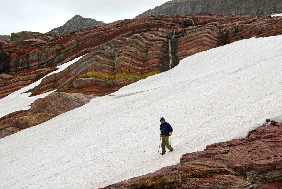 Term: subside, basin, Precambrian Era, bioturbated Sources: Alt, David, and Donald W. Hyndman. Northwest Exposures. Missoula, Montana: Mountain Press Publishing, 1995. Evans, K.V., Aleinikoff, J.N., Obradovich, J.D., and Fanning, C.M., 2000, SHRIMP U-Pb geochronology of volcanic rocks, Belt Supergroup, western Montana; evidence for rapid deposition of sedimentary strata: Canadian Journal of Earth Sciences, v. 37, no. 9, p. 1287-1300.
Ross, G.M., and Villeneuve, M., 2003, Provenance of the Mesoproterozoic (1.45 Ga) Belt Basin (western North America): Another piece in the pre-Rodinia paleogeographic puzzle: Geological Society of America Bulletin, v. 115, p. 1191-1217. . |
 |
Fossil Algae in the Belt Formation |
|
The Purcell Sill in Glacier Park |
|
*More about the Belt Supergroup |
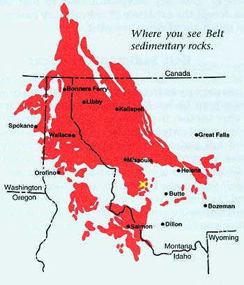 Map courtesy of Mountain Press Publishing in Missoula, Montana: This map was borrowed from Northwest Exposures, a great resource for anyone wishing to learn more about the geologic past of the Northwest. The yellow X indicates where the photo at the top of this page was taken. The authors David Alt and Donald Hyndman contend that the Belt Basin (a.k.a. the Belt Sea) was a roughly circular area found on the continent, and that it continued to subside as sediments accumulated. Recent radiometric measurements indicate that the sediment was deposited from 1.470 billion years ago to 1.400 billion years ago (Evans et al., 2000; Ross and Villeneuve, 2003). This is a far shorter time interval than previous interpretations from the late 1960s, which suggested that the sediment was deposited between 1.5 billion years ago and 800 million years ago.