|
Strip
Mine Helps Power This Computer 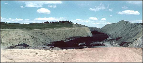
No need to go underground . . .
This photo shows a coal "strip mine" located near Colstrip, 90 miles east of Billings. Known to geologists as the "Powder River Basin," this region contains thick seams of coal that formed as coastal swamps were buried by sediments millions of years ago. Strip mining can be used in this area because the coal seams are closer to the surface than seams located in the eastern United States where underground coal mines are more common. Strip mining is much safer because miners do not have to go underground where collapses, gas explosions, and lung diseases are risks.
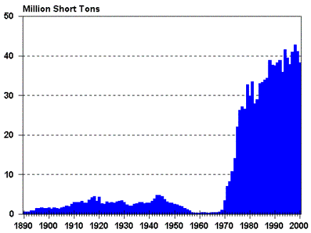 The 1970's brought changes . . . The 1970's brought changes . . .
The majority of coal mined in the U.S. is from seams varying in thickness from 3 to 10 feet, although the seams in the Powder River Basin of southeastern Montana and northeastern Wyoming average 40 feet in thickness. Mining of this region's low-sulfur coal increased drastically in the early 1970s when the Clean air Act mandated that industries decrease emissions of sulfur dioxide, a gas that contributes to acid rain. The graph on the right shows how much coal was mined in Montana during the 1900's. The increase in the 1970's centered around the town of Colstrip - and in Wyoming, the town of Gillette became the hub of coal mining activity. Although Montana has more coal than any other state (detailed list), Wyoming leads the way in the amount of coal mined. One reason for this is that Montana has a significant tax on coal sales, called the "Coal Severance Tax." Money collected from this tax is saved in a state "trust fund" for future generations.
Fossil Fuels . . .
Much of the coal mined near Colstrip is burned to generate electricity at a power plant (4 large generators) located on the edge of town. The rest is loaded onto trains and shipped to power plants in other states. Coal, along with petroleum (oil), and natural gas are called "fossil fuels." Oil is used to make liquid fuels for trains, planes, and automobiles, and much of the natural gas is piped into homes where it is burned to heat air and water in furnaces and water heaters. Coal is not our only source of electricity, but coal-fired generators like those at Colstrip provide over half of the electricity used in Montana. Hydroelectric dams provide the next biggest portion for Montanans. Nuclear plants (none in Montana) and wind generators are two other sources of electricity in the USA. Fossil fuels have been a focal point in the debate over global warming because carbon dioxide is emitted into the air as fossil fuels are burned. According to the "greenhouse theory" this carbon dioxide traps heat in our atmosphere, warming the world.
Is "carbon capture" in Montana's future? . . .
Because of the global warming issue and other environmental concerns, there has been strong resistance to the construction of new coal-fired generators in Montana in recent years. Many experts think that the future of Montana's vast coal resources depends on our ability to develop ways to capture and store carbon dioxide in rock formations beneath the ground. Called "carbon capture" (or carbon sequestration), this will involve collecting the carbon dioxide that presently goes out the tall stacks at generator plants and pumping it into the pore spaces found in rock layers (sandstone, etc.) far beneath the ground. Ideally there would be an impermeable "cap" (or cap layer) above the sandstone to prevent gases from escaping to the surface. "Carbon capture" was significant issue in the 2009 legislature, which took steps to help prepare Montana as a place where future carbon dioxide emissions from coal-fired plants cam be stored.
One Strip at a Time . . .
In the photo at the top of this page, a large truck sits on a
seam (layer of coal) that is ready to be mined. The long pile
of rock (spoils) to the
left is material recently removed from the
strip of coal. The spoils sit atop the seam that
was mined
before the strip shown in the photo was
exposed. After the exposed strip of coal is
removed, the area to
the right will become the next "strip". Its
topsoil has already been taken away and
stored. Next the
sedimentary rock (overburden) will be
broken up using explosives, and piled onto
the strip where the
truck sits. Eventually the broken up rock
will be smoothed out, the topsoil replaced,
and the area
will be seeded with native plants.
Source: Montana Power Company's
"Coal Fact Sheet" 1990
Can you figure it out? . . .
The diagram below is a cross-section of an area very similar to the area shown in the photo. Try to figure out which of the lettered areas on the diagram correspond to the following: coal, solid sedimentary rock layers, spoils, undisturbed topsoil, subsoil that has been returned, broken up rock that has been re-shaped, topsoil ready to be replanted, undisturbed subsoil. 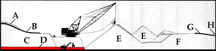
Terms: acid rain, emissions
|

