|
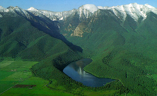
Lateral
Moraines formed by Valley
Glacier 
Postcard Photo by
Lawrence Dodge of Big Sky Magic
Enterprises
Evidence of an Valley Glacier . . .
This photo, taken 30 miles north of Missoula,
shows “lateral moraines” that were deposited
along the sides of a valley glacier (a.k.a. "alpine glacier") during the
last ice age. The moraines are the curved
ridges along the sides of Mission Reservoir.
These forested ridges consist of rock material
that the glacier removed from the mountains
in the upper part of the drainage basin, high
above the lake. Over the thousands of years since the moraine was formed, soil has formed on top and trees have taken root. A Conveyor Belt for Rocks . . .
Rock material that has
been transported and deposited by glaciers is
called "till". As the glacier formed, rocks
became stuck to its bottom and sides. Then
as the ice flowed toward the valley floor, these
rocks scoured away even more of the
mountain’s surface. The glacial ice flowed to
the position marked by the location of lake
where it melted and dropped the rocks. For
thousands of years, snowfall continued to
replace the ice as it flowed away from the
mountain tops. This "conveyor belt" took
much of the mountain with it, forming the
moraines. Much of the till deposited at the
end of the glacier was washed away as the
ice melted, so the "end moraine” is missing.
Since the end of the last ice age (10,000 years
ago), soil has developed on the lateral
moraines and trees have taken root.
Geologists describe till as “unsorted”
because it is made up of all sizes of rocks.
This characteristic helps geologists
distinguish materials deposited by glaciers
from those deposited by running water, which
tends to deposit different sizes of rocks in
different areas.
NOTE: The Mission Reservoir is about 3
miles in length. It can be found on the
Flathead Indian Reservation, 5 miles east of
St. Ignatius.
Terms: lateral, till
| 


