
|
Photo by Don Hyndman,
courtesy of the University of
Montana One of the most fascinating events of the last ice age was a series of cataclysmic floods associated with Glacial Lake Missoula. The shorelines of the ancient lake can be seen along the some of mountainsides around Missoula. In the photo shown above, the light snow on Mt. Jumbo makes it easier to see these ancient shorelines. At times the lake was 950 feet deep where Missoula sits today.
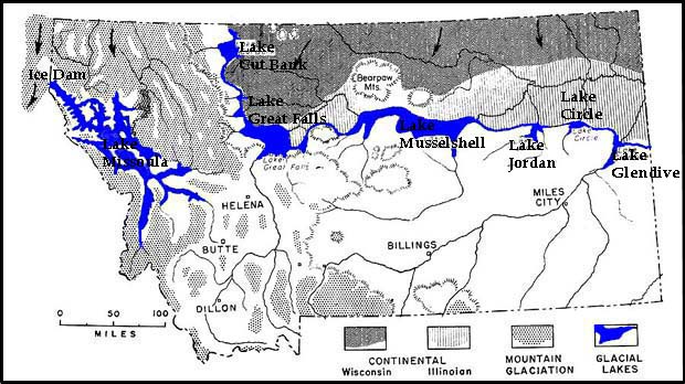
Here's what happened . . . When the Lake Missoula was at its highest, the water was about 2,000 feet deep and contained about as much water as Lake Erie. The lake extended as far south as Drummond in the Clark Fork Valley and Darby in the Bitterroot Valley. But, once the water filled in the area behind the ice dam, the lake didn't last for long. Since ice floats, it doesn't make for a very durable dam. Consequently, it was only a matter of time before the lake dislodged its ice dam. With the dam displaced, the 480 cubic miles of water impounded behind it would have been unleashed in a cataclysmic flash flood of incredible proportions. Starting at Pend Orielle Lake the water would have thundered through present-day Spokane and continued across eastern Washington to the Columbia River, scouring the land as it swept through. Geologists think that once this happened many times. Once the front of the glacier was swept away by the water it had impounded, the lobe of ice grew back into the area and re-dammed the river. Geologists believe that at Lake Missoula formed and flooded at least 41 times between 15,500 and 13,200 years ago. Below: Glacial Lake Missoula wasn't the only glacial lake. Several others existed along the southern edge of the ice.  Map courtesy of Montana Bureau of Mines and Geology Also . .
. Term: cataclysmic, catastrophic
|

 |
*A virtual tour of Glacial Lake Missoula |
 |
List of past pictures of the week |
 |
Next picture of the week |
 |
RETURN TO BASE CAMP |
|
Earth Science Teacher at Helena High School |