|
Glacial Trough in Southcentral
Montana
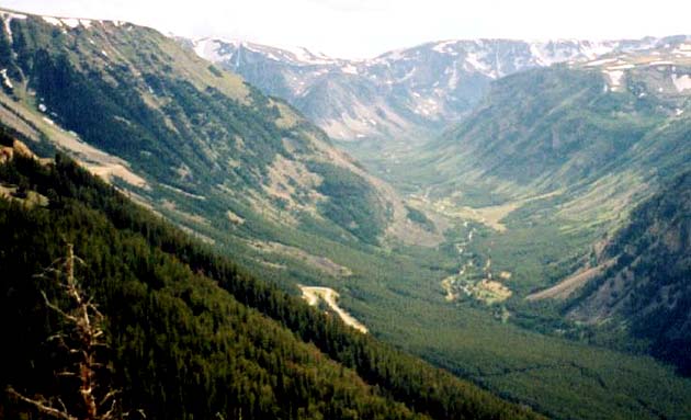
This photo was taken along the Beartooth
Highway about 20 miles southwest of Red
Lodge (as the crow flies) and 5 miles north of
the Wyoming border. A portion of the highway
is visible just to the left of the photo’s center.
The Beartooth Highway and the Going To the
Sun Road in Glacier National Park are two of
the most scenic drives in the USA.
Gimmie a ”V”! . . . Or is that “U”? . . .
The valley shown in the photo is a great
example of a “glacial trough” sculpted by an
alpine glacier that flowed though here during
the last ice age over 10,000 years ago.
Valleys carved by rivers in mountainous areas
tend to have distinct V-shapes, whereas those
shaped by glaciers tend to be U-shaped.
During the ice ages glaciers formed in
Montana’s high mountainous areas near the
upper portions of river basins and then flowed
down through river valleys. Along the way the
glaciers plucked rock material from the valley
walls, widening and re-shaping them as they
plowed through.
Where melting equals movement. .
.
Eventually, as these glaciers flowed out of the
mountains they reached elevations where they
began to melt back as fast as they were
flowing downward. While the climate was
stable, the front (toe) of the glacier stayed in
one place for decades. As a result any rocks
that were embedded in the ice and stuck to
the bottom or the sides of the glacier were
deposited there, forming a ridge of rock
material called an end moraine. For the
glacier that widened this valley the moraine is
located about 12 miles north of Red Lodge.
Since we are in what paleoclimatologists refer
to as an interglacial period, a river (Rock
Creek) once again occupies the U-shaped
trough.
Don’t be in such a hurry!. . .
The Beartooth Scenic Highway, also known as
(the Cooke City
Highway”) is a drive that every Montanan
should take. If you don’t stop, it takes bout
2.5 hours to get from Billings to
Cooke City. But don’t hurry! Be sure to take
several stops along the way, including the
beautiful “scenic turnout” where this photo
was taken from. The turnout has a nice
parking lot, restrooms, and a walkway that
offers breathtaking views of the valley below
and the surrounding Beartooth Plateau. The
short walkway is constructed primarily of
gneiss, a rock formed as granite is changed
by heat and/or pressure. To take the highway,
turn south at Laurel and continue south
through Red Lodge.
Terms: interglacial period, alpine
| 
