
|
Map courtesy of Johns Hopkins University
A dubious distinction . . .
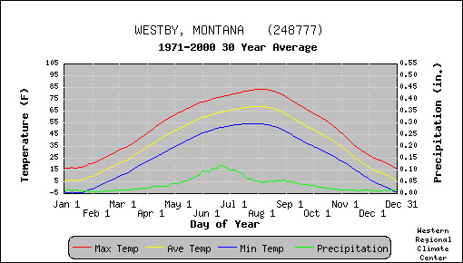
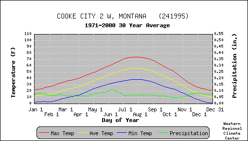
Climate factors . . . latitude . . . . . . . . . . . . . . . . elevationWhich climate factors? . . . For the towns in question a few climate factors must be taken into consideration. Elevation is a huge influence when it comes to temperature. Towns located at higher altitudes tend to have colder temperatures than towns at lower elevations. Here are approximate the elevations of the towns in question (given in feet above sea level). Wisdom: 6,100 ft. . . . Westby: 1,900 ft. . . . West Yellowstone: 7,000 ft. . . . Cooke City: 8,000 ft. Another consideration is latitude. Obviously Westby is the farthest north of the four towns. A third consideration is prevailing winds. In Montana the wind usually blows from the west, southwest, or northwest. Since winds are names by the direction that they are coming from, our wind belt is known as the "westerlies".
The Canadians are coming . . .
Climate graphs (below) . . .  . . Term: annual temperature range
|

 |
*Montana Climate Summaries |
 |
Past Pictures of the week |
 |
Next Picture: Fault Scarp near Helena |
|
Earth Science Teacher at Helena High School |