|
Helena has its
faults. 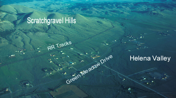
Photo courtesy of Mike
Stickney
Montana Bureau of Mines and
Geology
A torn surface . . .
This aerial photo shows the western edge of
the Helena Valley just a few miles north of
Helena. If you look closely you can see an
elevation change in the surface along a line
between (and parallel to) the railroad tracks
and Green
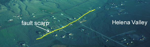
Meadow Drive. If you can’t tell where it is,
scroll down to see the labeled photo near the
bottom of this page. The linear feature, called
the Iron Gulch fault scarp, is where the ground
surface has dropped three to four meters
above a “normal fault” as a result of
earthquakes over the last 130,000 years. It is
not known how many quakes it took to form
the Iron Gulch scarp, but it could probably be
determined by careful study if a trench were
dug across the scarp.
 One quake at a time . . .
Earthquakes happen when there is movement
along a fault, however, not all movements
cause scarps to form. For example, during
the historic quakes that rocked Helena in
1935-1936 there were no surface ruptures. In
contrast, a big earthquake near West
Yellowstone in 1959 caused several new
scarps, including one that was 14 miles long
and as high as 21 feet (see Hot Link below).
Like most fault scarps, the Iron Gulch scarp is
not in solid rock, but rather in gravels and soil
above the bedrock. The actual fault is located
within bedrock, buried beneath soil and
hundreds of feet of gravel.
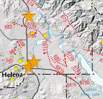
Map courtesy of Montana Bureau of Mines
and Geology . . .
The map at the right
shows faults (dashed lines) that have been
identified in the Helena area as well as
post-1982 epicenters (yellow circles). The
stars mark epicenters of post-1900
earthquakes with magnitudes of 5.5 or
greater. Some geologists believe that the Iron
Gulch fault (#683) extends to the southeast in
the subsurface, all the way to East Helena. All
of the faults shown on the map played a role
in the formation of the valley. Like many
basins in the northern Rockies, over millions
of years, the block(s) of bedrock that the
Helena Valley sits on has dropped down one
earthquake at a time along these faults to
form a basin surrounded by mountains (called
a graben). Since its formation the Helena
Valley has filled with gravels, sands, and silts
washed down from the surrounding
mountains. As Helenans learned during the
1935 quakes, structures built on these deep,
loose sediments shake much more violently
than structures built where bedrock is not far
below the surface.
.
 Supported by Internet
Montana
Supported by Internet
Montana
Terms: graben, normal fault
|

