|
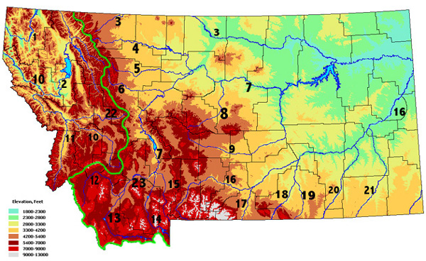
Map courtesy of Natural Resource Information System Take the quiz . . . This map that shows the location of Montana's major rivers. Put the numbers 1-23 on a piece of paper and then see how many you can name. Next, click on the Hot Link below to check your answers. The "big three" . . . Runoff from the land in Montana ends up flowing into one of three major rivers; the Clark Fork (#10), the Missouri (#7), or the Yellowstone (#16). Although the Clark Fork watershed is smaller than the areas that drain into either of the other two, the Clark Fork carries the more water out of our state than either of the other two. The reason for this is that moist air masses enter Montana from the west. The mountains of west of the divide (green line) make this air rise, causing clouds to form as the air cools by expansion. The result is that more precipitation falls in the Clark Fork Basin. Tributaries . . . Each of the smaller rivers drain into one of the "big three". For instance, the Musselshell River (#9) is a tributary of the Missouri and the Powder River (#21) flows into the Yellowstone. The Yellowstone is a tributary of the Missouri. The confluence of the Missouri and the Yellowstone is located in North Dakota, just east of the Montana border. From that point on the Missouri keep its name because it has a greater natural average flow (discharge). The Great Divide . . . Some people think that all rivers flow toward the equator, perhaps because they incorrectly think that south and "down" are the same thing. Actually the only general rule governing flow direction is that "water always flows downhill." The colors on this map indicate elevation (whites and reds are higher). Although the rivers on the map do not have arrows on them, the elevations should help you figure out which direction each of the rivers is flowing. Rivers start in higher elevations and flow toward lower elevations. The continental divide (green line on map) marks the boundary between runoff that flows into the Pacific Ocean (Clark Fork empties into Columbia River) and water that flows into the Gulf of Mexico (Missouri River empties into Mississippi River). A small portion of Glacier National Park drains into the Hudson Bay of Canada. (see Hot Link to Triple divide Peak) Term: runoff, discharge (of a river) |
 |
Answers to the rivers quiz |
|
*Surf your watershed |
|
*The Watershed of the Yellowstone River |
|
Past Pictures of the Week |
|
*Clark Fork River |
|
*Montana Watershed Organizations |
|
Triple Divide Peak |
|
Next picture |
|
Earth Science Teacher at Helena High School |