|
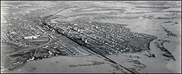
Floodwaters
surround Glasgow in 1952

Photo by Paul Monson, courtesy of Cole’s
Studio
with thanks to Samar Fay of the
Glasgow Courier
This photo shows how levees protected
Glasgow during a flood that occurred in April
of 1952. The camera was pointed toward the
southeast. Glasgow is located on the
floodplain of the lower Milk River, about 15
miles northwest of where the Milk empties into
the Missouri. Although flooding occurred as
far west as Havre, less that a dozen people
were injured and property damage was less
than $7 million. As the photo shows, levees
built around much of the town’s perimeter
prevented it from being inundated. Levees are
man-made embankments that protect towns
or agricultural areas from flood damage.
March weather helps out in 2004 . .
.
During the early spring of 2004 there were concerns that
the Glasgow area would have a flood similar
to the 1952 event because record amounts of
snow (67.7 inches) at Glasgow exceeded
those of the winter of 1951-1952 by over 7
inches. Fortunately, nearly perfect
temperature conditions during March caused the
snow to melt slowly, allowing the area to avoid
a flood similar to the one experienced in 1952.
Montana’s flood of the century . . .
The worst flood disaster in Montana’s history
happened in June of 1964 along both sides of
the Continental Divide in the northwestern part
of the state. As much as 14 inches of rain fell
in 36 hours, adding runoff to streams that
were already swollen because of snowmelt.
The result was 30 deaths and $55 million in
damage, including the failure of two irrigations
dams. One of the dams, located near
Dupuyer (75 miles northwest of Great Falls)
washed away, causing a flash flood that took
19 lives.
Terms: floodplain, levee, runoff
|


