
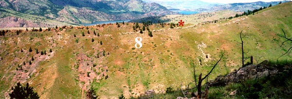
 Above: This view from the opposite side of Mann Gulch shows the approximate place (red asterisk) where Rumsey and Sallee crossed over into Rescue Gulch. The number "8" marks the general location of Dodge's escape fire. The Missouri River can be seen in the distance. In 2009 I returned to Mann Gulch with a friend to see if we could locate the place where Dodge set his fire by making measurements from Sylvia's rock as Laird Robinson and Norman Maclean did in 1979. See what we discovered: Click here to watch the 3.5 minute video, and then Click here to see what the area down-slope from the spot fire looks like now compared to 1949.
|

